Daylight saving ended overnight giving us an extra hour’s rest and we left at 9am. After collecting our photos – not too expensive this time – and buying placemats, we walked further around Lake Te Anau hoping to come to the Wildlife Centre where we would be able to see the takahe, a flightless bird once thought to be extinct. We didn’t find it so set out for the far south.
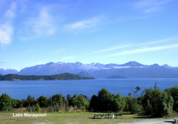
Our first stop was at Lake Manapouri 20km from Te Anau. With the Cathedral Mountains in the distance this lake is often referred to as the ‘loveliest’ in New Zealand and we would agree with that. We saw the departure wharf for the Doubtful Sound cruises then continued to Mossburn on SH94, where we stopped for smoko. This area is known as the ‘Deer Capital of New Zealand’. We passed many deer farms and could have bought fresh venison and venison pies at Bracken Hall the tourist stop near the park. There was a large processing plant nearby.
We turned onto SH6 at Lumsden and continued on through flat farmland to Winton where we stopped for lunch. As it was Sunday not much was open in this fairly large town. There were many old buildings, not all in good repair, which it would have been nice to see more of. We had very tasty Chinese food in the park, saw a gypsy caravan then continued on to Invercargill.
Invercargill is the southernmost city in the world. Hardy Scots who trekked south from Otago founded it in 1856. There is now a population of 50,000 and we had planned to spend the afternoon there but were most un-impressed. We parked near the centre and walked around several city blocks finding it very cold – as expected – although the locals were in summer clothes. The only interesting thing we saw was an unusual sundial built for the millennium. Returning to the car we put on our coats, which made it a bit better, and walked across a park to the Southland Museum. Situated at the entrance of Queens Park this appears to be the main attraction in Invercargill. From the gates of Queens Park we could see the ‘city’s most impressive building’ a huge water tower. The park covers 81ha and is quite nice with, amongst other things, two rose gardens and a winter garden with cold climate plants including several different heathers.
We soon tired of this and left at 3.30pm to travel the 30km to Bluff, Invercargill’s port. As well as servicing general cargo ships the port is the home of fishing and oyster boats and is the departure point for the catamaran to Stewart Island. The area is famous for Bluff Oysters – evidently very nice if you like oysters. Our accommodation for the night was at Lands End B&B. Situated at Stirling Point, at the end of SH1 near the famous signpost, Land’s End has uninterrupted views of Stewart Island and the Foveaux Strait. The people here were very friendly and there was a ramp from the car park to our room on the top floor.
We drove back into the small town, where a fishing contest was being held, and up to the lookout from where, if you weren’t blown off, you had 360o views. We were particularly interested it the Aluminium Smelter at Tiwai Point as Ron was once given the option of working there. I’m glad we went to Sydney instead, but Bluff – although cold – seemed a friendly place. Even now daylight saving had finished it was still light and we left Land’s End at 6pm to walk along The Foveaux Walkway which took us through native bush and around the coast. Had we kept going we could have walked to the Lookout! That evening we had a nice dinner in the Land’s End restaurant.
Next morning after a leisurely breakfast and a browse around the gift shop we left to visit the Paua Shell House in Bluff. This began as a way to exhibit a large collection of Paua taken mainly from the waters around Doubtfull Sound. They were collected on camping trips that would last for weeks. Once while the owner was away shelling his wife became tired of moving the shells around to dust and stuck some to the wall. When her husband returned he thought they looked great and eventually covered the entire walls of several rooms in Paua. Although the owner passed away almost two years ago the family are continuing to open the house to visitors and hope to be able to upgrade the large shell collection.
After a long conversation with a local passer-by – I said they were friendly – we followed the Southern Scenic Route to the Catlins. The region’s namesake was a ship’s captain who regularly carried exports to Australia and purchased a large tract of land from local Maori in 1840. Early settlers exported wool, grain and timber. Saw milling was the main industry but today – with sawmills gone- the area relies on farming, fishing and tourism.
Some of the roads in the area are unsealed but well maintained and our first detour down one of these was to Waipapa Point. Here we were able to walk up to two Hooker sea lions, New Zealand’s largest native mammal, sunning themselves on the beach. They were too sleepy to be interested in us. Wild and windy, with great drifts of bull kelp, Slope point is the southern-most point of the south island and a stopping place for most tourists. Returning to the main road we stopped at Waikawa and had our lunch overlooking the beach and breakwater before following another unsealed road to Curio Bay. Here the extensive fossilised remains of a 160-million-year-old forest, which was buried by a volcanic eruption, can be seen embedded in the rocks at low tide. Over the years the wood has been replaced by silica but the structure of the trees remain. This is one of only two petrified forests in the sea in the world. On low tide one is able to walk to it but unfortunately the tide was only out far enough for us to catch glimpses from the lookout.
Detouring 7km down a narrow farm road we came to McLean Falls. One of several falls on the Catlin Coast, we had been advised this was the best one to visit at this time of the year. The walk/climb of 1.75km took us 30 minutes (we were getting faster). It was very steep in places and there was quite a lot of water flowing over the falls.
We passed through Papatowai, where we bought petrol, and Balclutha, which was quite a large town, before leaving the Catlins and heading north toward Dunedin. There were many more interesting areas we could have explored along the way. One would need a week there.
Arriving at Dunedin at 6pm we had no trouble finding Hulmes Court B&B near the centre of the city, which was to be our home for two nights. Hulmes Court was staffed mostly be university students so it was not like the usual B&B, and although they were friendly and helpful it was not as personal. There was a large breakfast room, which guests could us any time and free Internet access was provided so we took the opportunity to write some letters while we were there. The small parking area at the back was reached by a very steep drive and coming back up was a worry!
Many cities have a square in the middle of town, but Dunedin has an octagon – an eight- sided centrepiece. We walked about 10 mins to the city centre and visited the information centre where we booked a tour for the next day and got ‘Aussie Proof’ maps and brochures.
Three hundred and forty colonists from Scotland founded Dunedin in 1848 at the head of Otago Harbour. About 12,500 immigrants arrived during the 1850s, most of them Presbyterian Scots and their families. Following the 1860s gold rush it became the largest and wealthiest city in New Zealand and the country’s first University was founded there in 1869. Today it is known as a University City with large numbers of students. With a population of around 20,000 the Scottish ancestry is still apparent in the accent of the locals. New Zealand’s only kilt shop is also there.
Next morning we set out early to follow the walking trail around the city, first passing St Paul’s Cathedral then, following the map, through The Octagon with it’s bronze statue of Robbie Burns which was erected in 1877, around the streets to Bell Hill which, in 1867,was lowered 40ft by convicts using picks and shovels prior to the building of the First Presbyterian Church of Otago. This church, with its 60mt spire, took 6 years to build. We continued on to the Railway Station, completed in 1906. With it’s ornate exterior, copper domes and lions perched on the clock tower it resulted in its architect George Troup earning the nickname of ‘Gingerbread George’. Inside there is an amazing Royal Doulton mosaic floor in the spacious foyer, which is decorated with Majolica tiles and stained-glass windows depicting steam locomotives.
Returning past the Law Courts, which were being renovated, and the Kilt Shop, we made our way back to Hulmes Court – up quite a steep hill – and after smoko left to drive around the Otago Peninsula.
Taking Highcliff Road, with views over Otago Harbour and Dunedin, we came to Larnach Castle, New Zealand’s only castle, with 35 acres of garden. William Larnach, a banker and politician who had made his fortune at the Australian Gold Fields, began construction in 1871 for his wife Eliza. 200 workmen laboured for three years before the family moved in and craftsmen continued for another 12 years embellishing the interior. The Ballroom was added in 1887 as a 21st birthday gift for daughter Katie. After Eliza died aged 38, William married her half-sister who also died young after which he married again.
There was an unsubstantiated rumour that his third wife was having an affair with his second son, which is believed to be what led him to commit suicide in his office at Parliament in Wellington. The family moved away and the castle was in a state of decay when the present owners, the Barker family, purchased the property in 1967. Extensive restoration has been done to bring it back to its former glory and many original pieces have been bought or are on loan. The Georgian hanging staircase, the only one in the southern hemisphere, with balustrades of mahogany and a curved handrail carved from solid kauri was lovingly restored and leads up to the nursery floor. From here there is a narrow spiral stone staircase up to the battlements where, at 320m above sea level, there are panoramas of Dunedin and down the harbour to the heads. After lunch in the ballroom, a walk around the gardens and visiting the castle we continued up the Peninsula to Portobello where we came to Harrington Road, which led on – very close to the water in some places – to Tairoa Head. The Royal Albatross colony here is the only albatross colony in the world established on a mainland site. These giant birds, with a wingspan of more than 3m, normally breed in Antarctica. They arrive at Tairoa in September to mate and the chicks are born in January after which the parents are kept busy collecting food for them until they are ready to fly.
It was early afternoon but we saw one bird before continuing on to ‘Nature’s Wonders’ where we were to take a tour to try and see Hoiho the Yellow-eyed Penguins. These are the third largest penguins and the rarest in the world with the Otago Peninsula being home to the biggest concentration. The only other places they are found are a few remote Antarctic Islands. Efforts to counter the impact of predation and loss of habitat have been successful and now there are 45 – 60 nesting pairs on Penguin Beach. We were fitted out with coats with hoods to protect us from the dust and with a guide driving an 8x8 Argo we set off to see the wildlife of the headland. The brochure said ‘while the ground may be rough in places, the ride certainly isn’t’- it lied. This vehicle could go anywhere, and did. We were behind two others so got plenty of dust, but we were in front on the way back! We passed a gun emplacement on the cliff, a relic of WWII, saw great views from the top of the hill, then came to the Seal Colony which we viewed from a hide. There is a plentiful supply of food in these waters for these New Zealand fur seals that live here all year round.
Continuing on we came to the hides above Penguin Beach. One lone penguin was way up in the sand dunes. We were told it had been there for some time as it was moulting and could not go to sea. Although it was by now almost 5pm it may have been a little early for the penguins to be returning home from the sea. There were several lying on the sand at the top of the beach and just as we were about to leave one came in from the water. The hides are a long way from the beach and it would be most unusual to see a penguin close by I think. However it was an unusual experience.
Returning to the Albatross Colony we were in time to see quite a few birds returning to their nests for the night and, after a cuppa, followed ‘the low road’ back around the harbour to Dunedin.
|